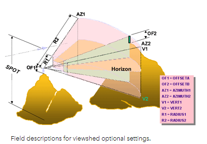
This module expanded on last week's Lidar data module. This week's topic was visibility analysis. It determines what can be seen from one or more locations. There are two kinds viewshed and line-of-sight analysis. The lectures were on visibility analysis and other Esri videos and presentations. However, the lab was different than other GIS labs. I had to complete four Esri online courses: Introduction to 3D Visualization, Performing Line of Sight Analysis, Performing Viewshed Analysis in ArcGIS Pro, Sharing 3D Content Using Scene Layer Packages. I thought they were very easy to follow and I enjoyed learning about Lidar and 3D visualization. Doing the course on sharing 3D content was helpful because I doubt I will learn that anywhere else. The line of sight course had a good workflow that I may want to reference when performing this kind of analysis on my own. Viewshed analysis parameters can be a bit confusing. The course had a nice chart and graphic describing what the different parameters controlled (see images below).

Comments
Post a Comment